Bryce P. Torres
GIS Advisor & Sr. GIS Analyst
Designing enterprise GIS solutions that improve operational efficiency and decision making.
About Me
With over 15 years of GIS experience in the oil and gas industry, I design and deliver enterprise GIS solutions that improve operational efficiency and support data-driven decision making. My work focuses on moving organizations beyond static maps to integrated systems that actively support field operations, planning, and strategic initiatives.
My expertise spans enterprise GIS administration, geodatabase management, web applications, dashboards, and field data collection workflows. I specialize in bridging technical GIS capabilities with business needs, working closely with cross-functional teams to design solutions that are scalable, intuitive, and widely adopted.
I bring deep expertise in enterprise geodatabase architecture, having designed complex schemas with domains, atrribute rules, subtypes, and relationship classes that serve as the foundation for organization-wide spatial data standards. My technical skillset spans advanced Survey123 development using Arcade expressions, spatial SQL optimization, and customization of Experience Builder and VertiGIS Studio. Beyond implementation, I've led multiple enterprise data migrations, managed vendor relationships with Esri and third-party consultants, and mentored teams to drive adoption of modern GIS workflows.
Based in Tulsa, Oklahoma, I currently serve as a GIS Advisor, helping organizations modernize their spatial infrastructure, automate manual processes, and fully leverage the value of their geographic data.
What I'm Known For
- Streamlining workflows that save teams hundreds of hours each year
- Designing intuitive GIS solutions that drive adoption across technical and nontechnical users
- Translating complex spatial challenges into clear, actionable business insights
- Automating manual processes to reduce errors, costs, and operational risk
- Designing scalable enterprise GIS solutions that integrate with broader business systems
- Architecting enterprise geodatabase schemas that scale across departments and operations
- Building advanced Survey123 forms with custom pulldata functions that eliminates data entry errors
- Optimizing database performance through spatial SQL queries and automated validation
- Leading enterprise data migrations that consolidate years of legacy data without disruption
- Integrating subsurface geological data with surface operations for comprehensive spatial analysis
Skills & Expertise
Enterprise GIS Administration
Development & Automation
Data & Analysis
Enterprise Solutions
Oil & Gas Expertise
Leadership & Strategy
Featured Projects
A selection of impactful GIS solutions I've designed and delivered.
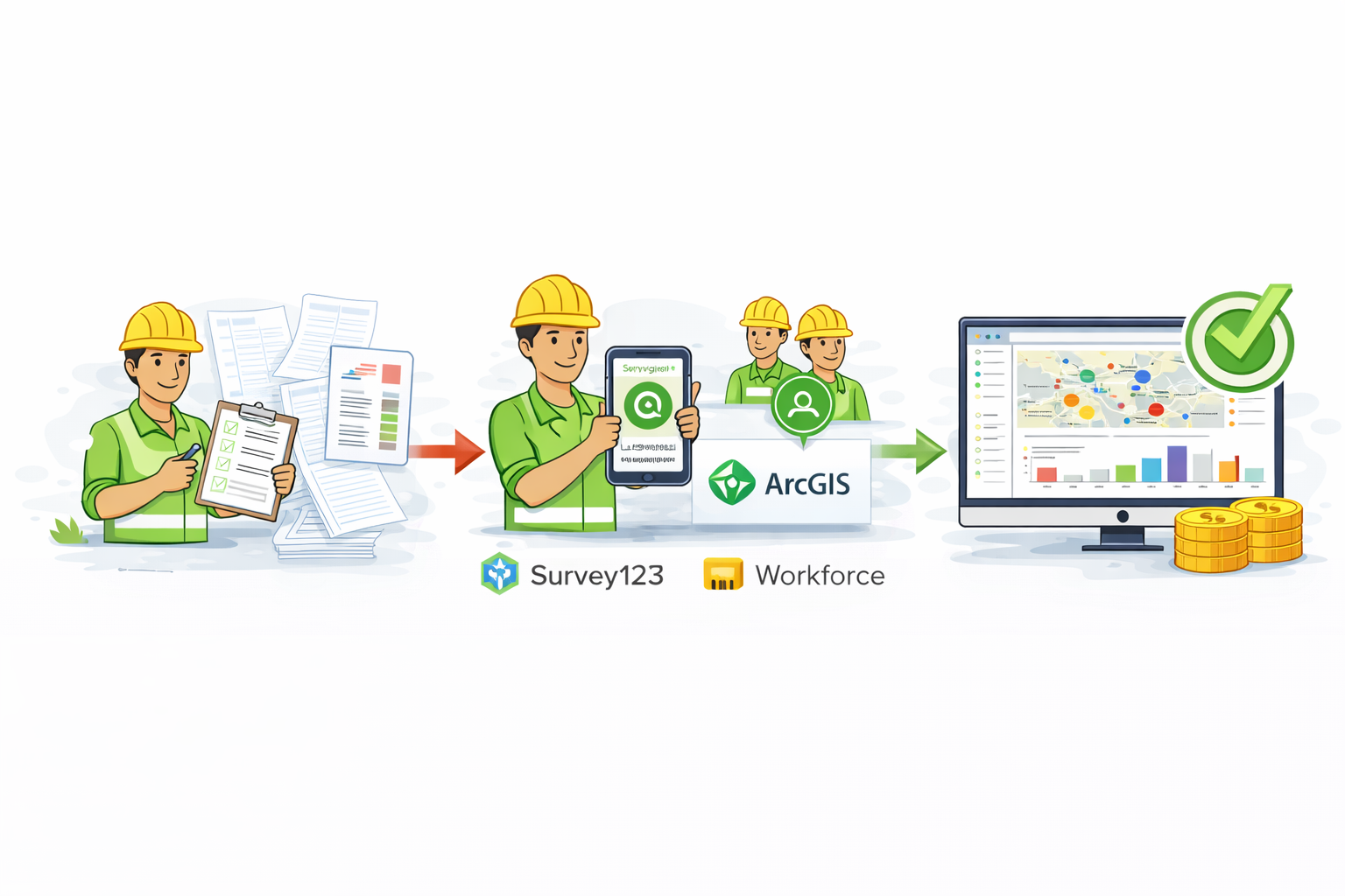
Air Quality Inspection Workflow
Cost Saving In House Inspection Workflow
- Problem: Air quality inspections relied on manual, paper based workflows that were time consuming and error-prone, resulting in inconsistent data, duplicate entry, and dependence on third-party hosted systems.
- Solution: Designed and implemented an integrated mobile inspection workflow using ArcGIS Enterprise that enabled real time inspection tracking, standardized data capture, and automated reporting.
- Impact: Reduced inspection time by 40% and eliminated reliance on external systems, saving over $100K annually while improving data accuracy and operational visibility.
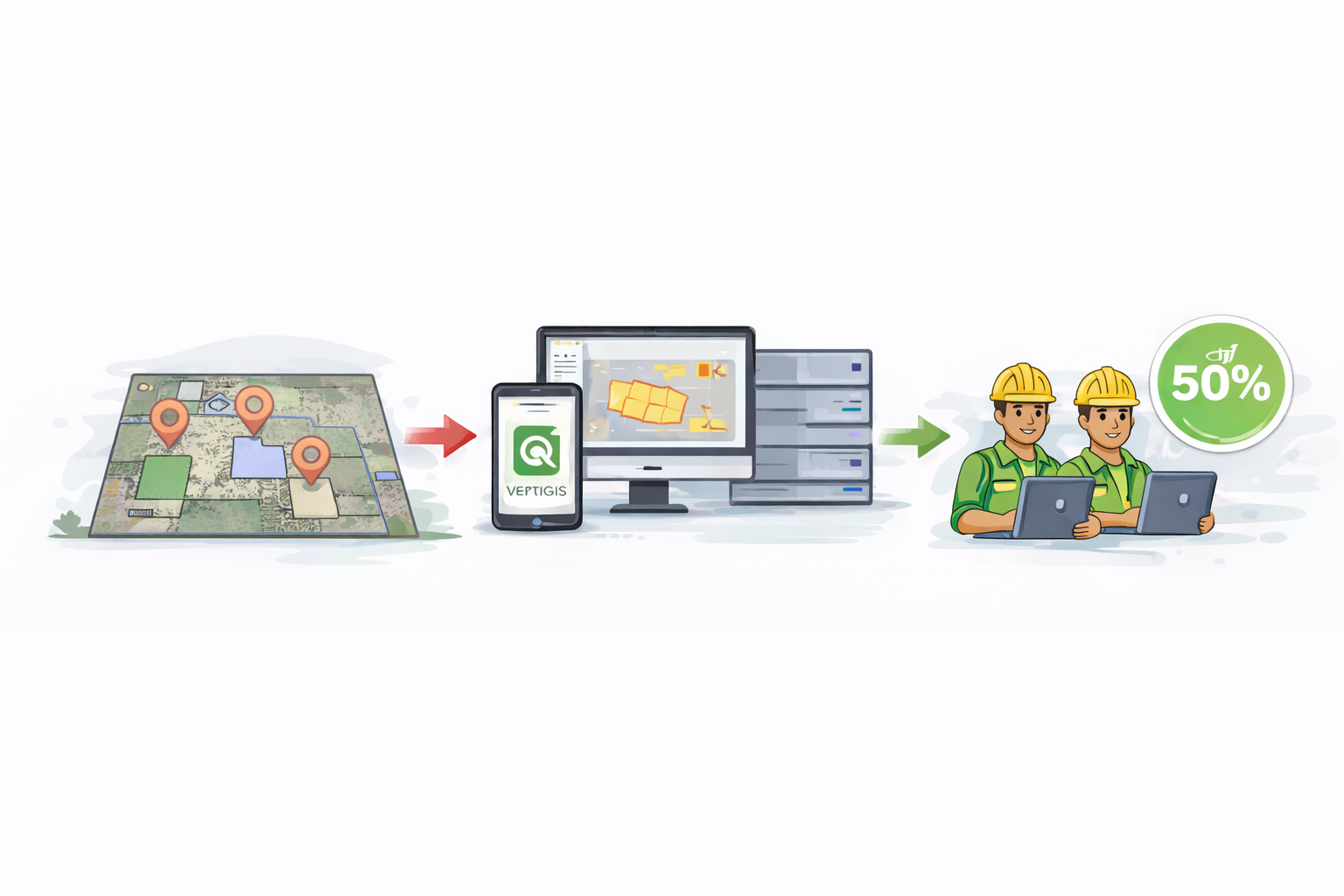
Field Design Web Application
Well & Facility Planning Platform
- Problem: Surface Land and Facility Engineers lacked a spatial tool for planning future well pad locations and facilities.
- Solution: Created a web based design workflow with integrated feature service layers and editing capabilities.
- Impact: Enabled field teams to collaborate on designs in real time, reducing planning cycles by 50%.
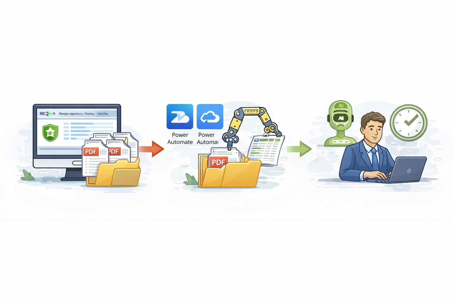
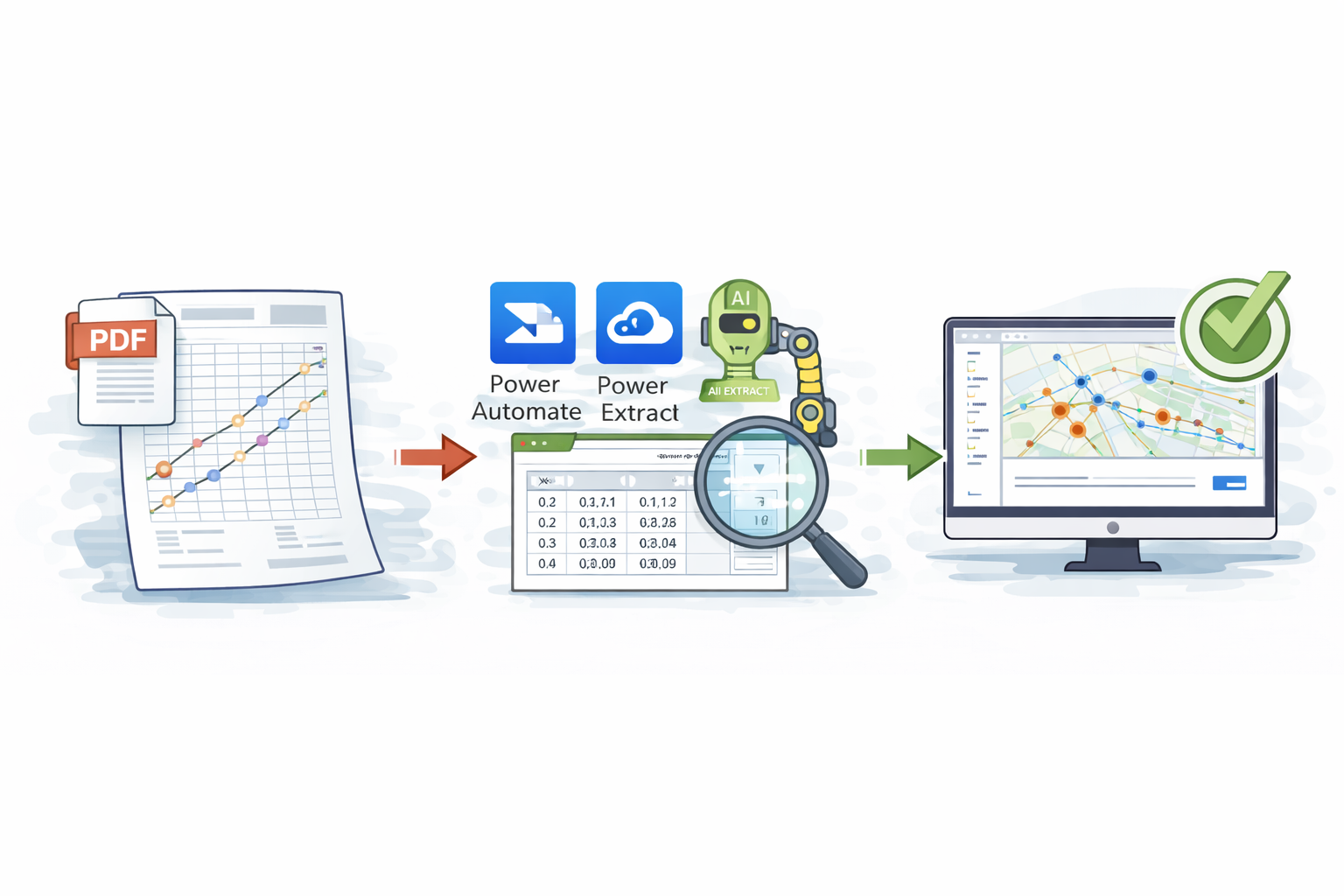
H-9 Permit Data Automation Extraction
Regulatory Compliance Automation
- Problem: Once a Texas Railroad Commission H-9 permit was approved, Regulatory staff were required to manually log into the TRRC website, search for permit criteria, open individual PDF documents, and manually transcribe permit details into internal spreadsheets. This process was time consuming, repetitive, and prone to data entry errors.
- Solution: Designed and implemented an RPA workflow that automatically retrieves approved TRRC H-9 PDF permits, organizes them into a structured folder system, and uses AI based document extraction to capture key permit data directly from the PDFs and populate a standardized spreadsheet.
- Impact: Eliminated manual data entry for H-9 permit tracking, significantly reducing processing time and transcription errors. The automation improved data consistency, increased regulatory efficiency, and allowed the Regulatory team to focus on higher value compliance and reporting tasks.
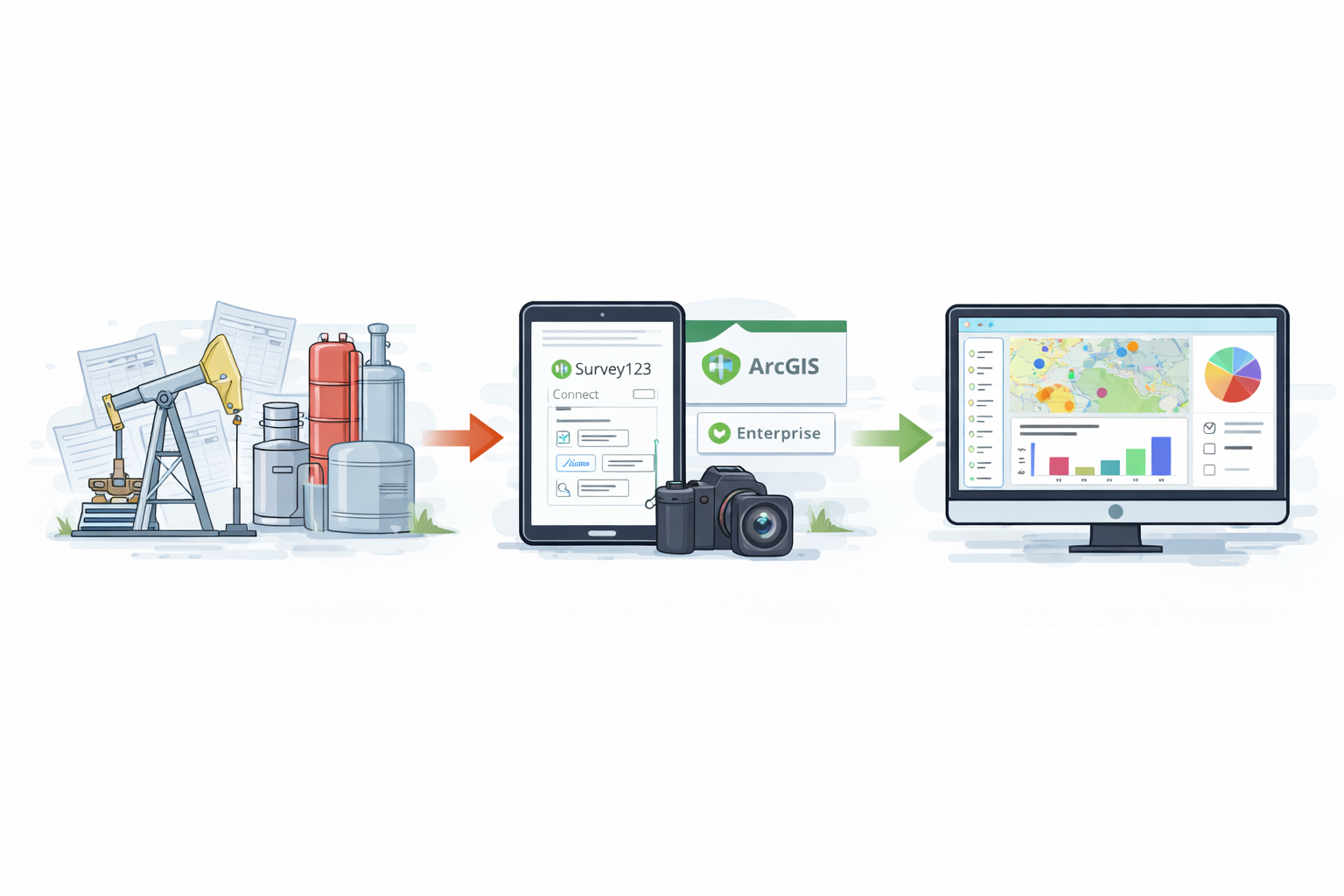
Midstream Field Data Collection
Enterprise Field Data Collection for Midstream Assets
- Problem: The Midstream team lacked a centralized, spatially enabled inventory of field equipment. Existing records were maintained in disconnected spreadsheets with no geographic context, leading to incomplete visibility into equipment locations, inconsistent data, and limited ability to analyze site level assets.
- Solution: Partnered with the Midstream team to define equipment data requirements and designed an enterprise field data collection solution using ArcGIS Enterprise. Built the underlying geodatabase schema in SDE, published a feature service, and developed a customized Survey123 Connect form. The form dynamically pulled location and asset attributes from existing web services based on spatial location or entered IDs, reducing manual entry, minimizing typos, and enforcing consistent data standards.
- Impact: Established the first authoritative, spatially accurate equipment inventory for Midstream operations. Field teams can now capture equipment details directly on site, including photos and videos, while leadership can view and analyze results through dashboards. The solution improved data accuracy, enabled site level visibility, and allowed teams to identify trends by equipment make and model to support better maintenance planning and asset decisions.
Automated Well Survey XY Validation Workflow
AI Driven Extraction and GIS Verification of Survey Plats
- Problem: Validating XY take points on horizontal well survey plats required GIS staff to manually transcribe dozens of coordinates from surveyor provided PDFs into GIS for verification. This process was highly time consuming, repetitive, and increased the risk of transcription errors when reviewing large batches of plats.
- Solution: Designed and implemented an RPA workflow using AI Extract to automatically capture XY take point coordinates directly from well survey plat PDFs into a structured spreadsheet. The extracted coordinates were then processed through GIS geoprocessing tools to generate spatial features and validate the accuracy of surveyor provided data against GIS records.
- Impact: Fully automated a previously manual quality control process, reducing validation time from hours to minutes for each batch of well survey plats. The solution improved accuracy, eliminated repetitive data entry, and freed up GIS staff to focus on higher value analysis, system improvements, and other critical projects.
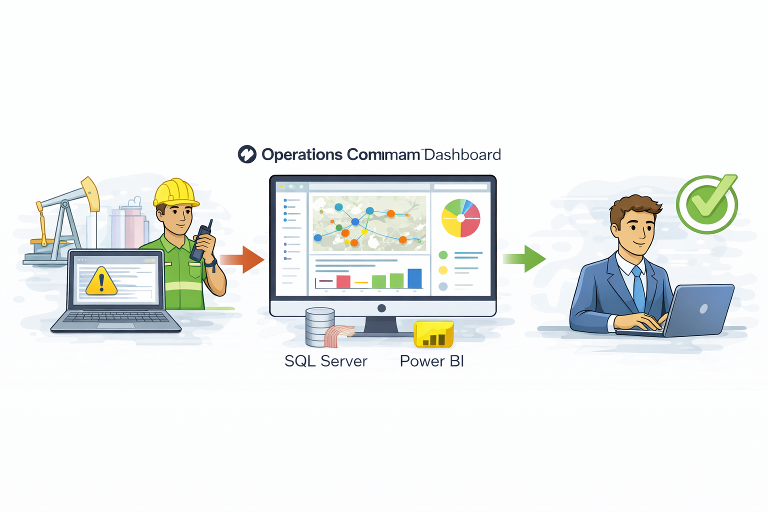
Operations Command Dashboard
Real Time Executive Visibility
- Problem: Leadership lacked real time visibility into field operations and asset status.
- Solution: Built interactive dashboards with live data feeds and KPI tracking.
- Impact: Enabled data-driven decisions and reduced status meeting time by 60%.
Career Evolution
From paper maps to enterprise GIS — a 15-year journey of continuous innovation.
2010 - 2011
Static GIS Foundations
Paper maps, basic digitization, terrain analysis, Google Earth
2011 - 2014
Early Enterprise GIS
Pipeline and facility mapping, CAD integration, GPS field collection
2014 - 2016
Web Maps and Adoption
Web maps, One Call workflows, company-wide GIS training
2016 - 2025
Automation and Integration
Feature services, dashboards, enterprise system integrations, automated workflows
2025 - Present
Modern Enterprise GIS
Field-first data collection, real time dashboards, cost saving in house solutions
Experience
15+ years of progressive GIS leadership in the energy sector.
GIS Advisor
Vital Energy
- Architected enterprise geodatabase schemas with complex domains, subtypes, and relationship classes to support cross-department data standardization and operational workflows
- Managed vendor relationships with Esri and third-party consultants to coordinate software upgrades, licensing agreements, and technical support
- Redesigned the air quality inspection process using Survey123, Workforce, and Dashboards, replacing external consultant solutions and delivering over $100,000 in annual cost savings
- Developed advanced Survey123 Connect forms with custom schemas, automated calculations, and integrated feature services to improve data accuracy and minimize manual entry
- Collaborated with EHS, Midstream, Drilling, Production, and Air Quality teams to expand mobile field data collection and standardize reporting across departments
- Directed the development of the Field Design web workflow, enabling land, facility engineering, and electrical teams to collaboratively plan and visualize future projects within a shared web map environment
Sr. GIS Analyst & Data Visualization
Vital Energy
- Led multiple enterprise data migrations, consolidating disparate datasets into unified SDE geodatabases while maintaining data integrity and minimizing operational downtime
- Executed spatial SQL queries and database optimizations to improve feature service performance and reduce query response times for enterprise users
- Administered ArcGIS Enterprise and enterprise geodatabases, managing Feature and Map Services and implementing automated data updates to ensure accurate, reliable enterprise GIS data
- Partnered with IT to lead Esri Enterprise upgrades, transitioning environments from internal to external networks to support new applications, integrations, and secure access
- Led the migration of company web maps to VertiGIS Studio and developed custom workflows for land and operations teams, increasing usability and driving adoption to over 50 percent
- Integrated GIS with enterprise systems including Quorum, Procount, FlowCal, SiteView, and Enverus to improve data flow, cross-system visibility, and analytical capabilities
- Built Power Automate workflows for One Call submissions, frac notifications, AI assisted survey plat checks, and regulatory processes, significantly reducing manual effort and operational workload
- Integrated subsurface data including well logs, formation tops, and directional surveys with surface GIS to support drilling operations and geological analysis
- Managed right of way, easement, and surface use agreement data to support land access planning and regulatory compliance
- Performed environmental impact analysis including habitat mapping and wetland proximity studies to support permitting and regulatory submissions
- Integrated production accounting data to map volumes, decline curves, and field level performance metrics for operational analysis and executive reporting
- Mentored junior GIS staff and trained non-GIS employees across operations, engineering, and regulatory teams on spatial tools, data standards, and best practices
GIS Analyst
Vital Energy
- Oversaw enterprise geodatabases, corporate web maps, One-Call processes, and T4 filings to support operational needs and regulatory compliance.
- Integrated and maintained spatial data from AutoCAD drawings and field sources, ensuring accurate representation of wells, pipelines, and utilities, and performing topology validation on road networks.
- Established geocoding services and address locators for wells, facilities, and field assets to support operational planning and regulatory reporting
- Utilized Spatial Analyst and Network Analyst extensions for proximity analysis, routing optimization, and site suitability modeling
- Delivered companywide GIS training to increase adoption and effective use of web maps and spatial tools.
GIS Analyst
Samson Resources
- Maintained pipeline and facility spatial datasets, supported company web maps, One Call workflows, and T4 filings, and integrated AutoCAD drawings to ensure accurate representation of wells, pipelines, roads, and utilities
- Delivered internal GIS training on web maps and mapbooks and supported GPS-based field data collection using GeoXT units to incorporate accurate location data into enterprise GIS systems
Contract GIS Coordinator
Williams Midstream
- Generated custom Google Earth KML layers from internal GIS datasets and analyzed LiDAR and DEM data to evaluate terrain elevation and slope
- Produced map products for engineering and field teams and delivered GIS and Google Earth training to staff across multiple locations
Let's Connect
I'm always open to connecting with organizations looking to strengthen their GIS capabilities. Whether you're hiring for an enterprise GIS role or exploring ways to modernize spatial workflows, I welcome the conversation.
- ✉ bryceptorres@gmail.com
- 🔗 LinkedIn Profile
- ⚲ Tulsa, OK
Quick Contact
Prefer a direct approach? Use these quick actions: